Reza Safarzadeh

I'm

About

Ph.D. Student in GeoSpatial Information Science

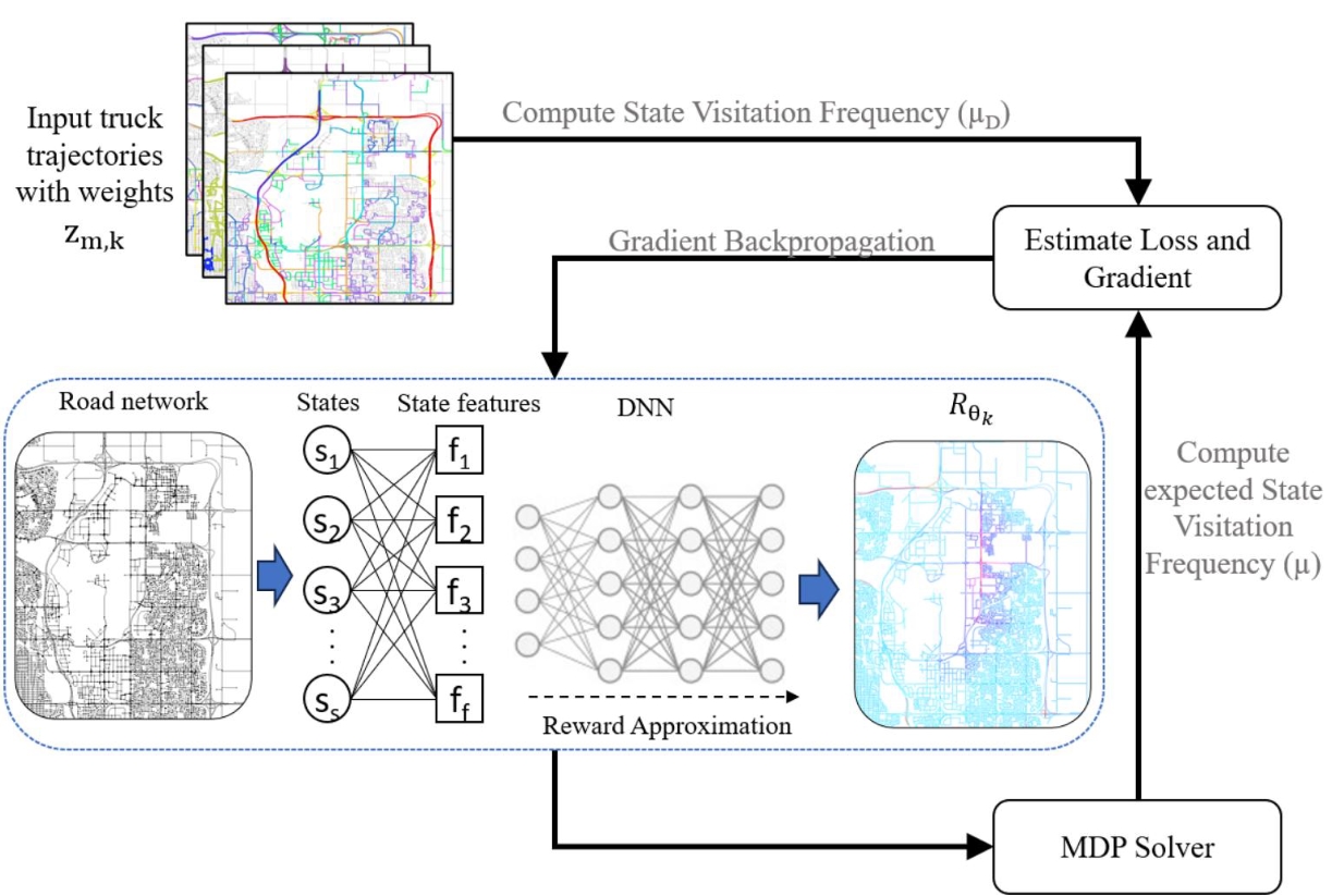
My current research lines are in the area of spatial trajectories analysis, vehicle movement analysis, and developing AI methods for smart transportation.

Hi, My name is Reza. I am a Ph.D. student at the Department of Geomatics Engineering, University of Calgary, Canada. I am currently working at the Intelligent Geospatial Data Mining Lab (IGDM) under the supervision and advisory of Prof. Xin Wang. I hold a master degree in Geospatial Information Systems (GIS) from the K.N.Toosi University of Technology and a bachelor of science in Geomatics Engineering from Iran University of Science and Technology (IUST). The focus of my current research as a Ph.D. student is on developing Artificial Intelligence (deep learning) methods for the improvement of smart transportation systems under extreme weather conditions. I have also spent over three years working at FANAP ICT as a senior spatial data analyst. Working within diverse industrial and academic environments helped me developing my technical and analytical expertise as well as academic skills. I took the opportunities to expand my knowledge of a range of data science methods and techniques, including and deep learning approaches (e.g. RNNs, GCNs, etc.), as well as various programming languages (such as Python, Java and Matlab).

If you want to know more about the projects I have done, contact me, check my Github, and see my Vitae.

Curriculum Vitae

Skills

GIS Software (ArcGIS, Qgis, etc.) 90%
Python (Programming Language) 90%
JavaScript (Programming Language) 80%
HTML, CSS 80%
DBMSs 60%
MATLAB (Programming Language) 60%
Machine Learning80%
Reinforcement Learning 80%
Deep Learning70%
Spatial Data Mining85%
Spatial Analysis80%
Spatial Optimization60%

EDUCATION AND EXPERIENCE

Education

PhD | Geographical Information Science (GIS)

2021 - Present

Geomatics Engineering Departmnet, Schulich School of Engineering , University of Calgary, Canada

Main responsibilities include developing novel geospatial AI algorithms and systems for logistics, such as smart route recommendation systems for transporting goods, and optimization of regional logistics networks for parcel delivery services.

Supervisor : Prof. Xin Wang

Master of Science (M.Sc.) | Geospatial Information Systems (GIS) Engineering

2014 - 2017

K.N.Toosi University of technology , Tehran, Iran

My master's program was heavily focoused on GIS, and offered courses in all areas of GIS. Fundamentals of GIS, Spatial Data Infrastructure, Web GIS, and Data Management are among the important courses I took in that program. I had the opportunity to do projects in all these fields, and conducted my Master's thesis research on Spatial Multi-Objective Optimization of urban land use allocation.

Supervisor : Prof. Mohammad Karimi

Bachelor of Science (B.Sc.) | Geodesy and Geomatics Engineering

2009 - 2013

Iran University of Science and Technology , Tehran, Iran

This program is a combination of Land Surveying, Geodesy, Photogrammetry, Remote Sensing, and GIS. I took courses in all these subdesciplines and that's when I became interested in GIS.

Professional Experience

GIS Specialist and Spatial data Analyst

2018 - 2021

FANAP ICT Subsidiary of Pasargad Financial Group, Tehran, Iran

  • Design and implementation of a GIS-Based approach to identify suitable location for establishing Automated Teller Machines (ATM) and Optimization of ATMs' network. Using spatial and statistical models, ArcGIS, QGIS, ArcGIS Model Builder and Python language for writing scripts and automation of model.
  • Developing an approach for control and monitoring of a fleet management system and web-based software to show the exact position of the desired vehicles on different maps and take detailed reports of the mission, travelled path, fuel consumption rate, speed limits, and other necessary information according to the company’s requests.
  • Real-time vehicle route planning (VRP) model for ATM cash replenishment vehicles.
  • Using spatial trajectory mining techniques to explore vehicle drivers’ behaviour and fraud detection
  • Using machine learning techniques for road network traffic prediction problem
  • Using HTML, JavaScript (Spatial libraries: ESRI JavaScript API, OpenLayers), Python (Spatial libraries: GDAL, Shapely, Pyproj, GeoPandas) and Java

GIS Specialist

2017 - 2018

AvayarSanat Co., Tehran, Iran

  • Design and implementation of spatial databases.
  • Producing specialized maps for different applications.
  • Using ARCGIS software, QGIS, GeoServer, MapServer, PostgreSQL, etc.

Publications

Reza Safarzadeh Ramhormozi, et al. Multi-Task Graph Neural Network for Truck Speed Prediction Under Extreme Weather Conditions.

2022 - 30th ACM SIGSPATIAL International Conference on Advances in Geographic Information Systems (ACM SIGSPATIAL 2022)

Abstract: Truck speed prediction plays a key role in truck transportation management. However, it is a very challenging task since the truck traffic usually shows complex patterns. Most of the existing traffic prediction methods lack the ability to model the dynamic spatial-temporal correlations of truck traffic or ignore contributing contextual factors that impact traffic ...

Safarzadeh Ramhormozi, R., Karimi, M., & Alaei, S. Multi Objective Optimization of Urban Land Use Allocation Using Meta-heuristic Algorithms and Spatial Metrics.

2018 - Journal of Geomatics Science and Technology, 7 (3) ,189-212.

Abstract: The main objective of this study is to support decision-making using multi objective Meta-heuristic algorithms for land use optimization and sorting the solutions with respect to the spatial pattern of urban growth. In the first step in this study, we applied the non-dominated sorting genetic algorithm ΙΙ (NSGA_II) ...

Projects

I am always interested in new projects related to spatial data analysis and spatial modeling, particularly in spatial data science, machine learning, big spatial data analysis, spatial modelling, and web development. Do not hesitate to contact me if you have an interesting research or development project.

  • All
  • GIS
  • Web

ATM GeoBI

GIS-Based web application to analyze identify suitable location for establishing Automated Teller Machines (ATM) and Optimization of ATMs' network.

Trackcar

Fleet Management System

Vehicle Route Planning (VRP)

Vechicle Route Planning and Trajectory Mining

Contact

Location:

2500 University Dr NW, Calgary, AB T2N 1N4

Call:

+1 403 708 5652

Loading
Your message has been sent. Thank you!